The Goal of Geophysical Exploration Methods
The goal of oil and gas exploration is to find hydrocarbon accumulations in commercial quantities. Petroleum geoscientists seek information from multiple sources in order to evaluate the numerous Elements and Processes which must be present for a successful petroleum system to exist within a sedimentary basin:
- Source Rock
- Migration route
- Reservoir
- Trap
- Seal
- Generation
- Migration
- Accumulation
- Preservation (permeability leakage over time)
SFD® surveys can be used to identify potential fluid-bearing anomalies, since the SFD® data generates unique information that is interpreted to assess attributes of reservoir quality, trap configuration and the presence of an effective seal.
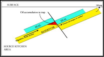
The graphic shown here (source: Wikipedia – Petroleum Geology) is an example of a structural trap, where a fault has juxtaposed a porous and permeable reservoir which holds hydrocarbon reserves against an impermeable seal layer. Oil (shown in red) accumulates against the seal (or low permeability cap rock), to the depth of the base of the seal. Any further oil migrating in from the source will escape to the surface and seep.
In general, all these elements must be assessed via a limited ‘window’ into the subsurface world, which is sometimes provided by one (or possibly more) exploration wells. These wells present only a one-dimensional segment through the Earth and inferring three-dimensional characteristics from them is one of the most fundamental skills in petroleum geology. Explorationists employ multiple geophysical methods, as each can provide unique information regarding the earth’s subsurface and the potential hydrocarbon prospects contained therein. These methods can be employed at various stages of the exploration cycle, and each can have widely different costs and timeframe to employ, depending on the location and difficulty of access of the prospect area. Each method provides unique information regarding density, resistivity, and other earth properties.
The use of multiple, complementary methods such as SFD® can provide additional confidence in the building of subsurface geological models, which aids in reducing exploration risks.
Other geophysical methods employed in hydrocarbon exploration include:
2D and 3D seismic data – reflection seismology is similar to sonar or echolocation, and requires a controlled source to emit a signal into the earth and an array of receivers to capture the signal as it is reflected back from strata in the subsurface. Processing and modeling of the data collected results in seismic images of the subsurface and the estimation of various rock properties.
Aeromagnetic and aerogravity methods – in exploration, magnetic and gravity data are typically acquired from an aircraft and thus termed “aeromagnetics” or “aerogravity” methods. Typically, the value of these methods lies in early stage exploration to map basin architecture. In most basins the underlying crystalline basement rocks have higher densities than the overlying sedimentary cover. By data processing, forward modeling and inversion of the gravity data, the “depth to basement” can be determined. An understanding of the basin architecture helps in developing hydrocarbon source/maturity models and in determining where to focus additional exploration effort.
Magnetometers – these are used to measure the magnetic susceptibility of materials which aids in mapping basin architecture. Additionally, magnetic data can be used to map fluid conduits due to associated mineralization effects.
Gravimeters – this method uses accelerometers (essentially a test mass on a spring) to measure variations in subsurface density, based on the acceleration caused by gravity between two or more measurement points. In most basins the underlying crystalline basement rocks have higher densities than the overlying sedimentary cover.
Full Tensor Gravity Gradiometry (“FTG”) – while conventional gravimetry systems measure one component of the gravity field in the vertical direction, FTG is a technique which uses multiple pairs of accelerometers to measure the derivative of the gravity field in all three principle axes. Measuring derivatives gives higher resolution gravity data but the process is inherently more sensitive to noise. By data processing, forward modeling and inversion, prospect-level gravity anomalies can be located.
Controlled Source Electromagnetic data (“CSEM”) – CSEM marine surveying is a geophysical method that is able to map resistive bodies in the subsurface of the earth by transmitting a low-frequency electromagnetic signal. The EM energy is quickly attenuated in conductive sediments, while in resistive layers which might contain hydrocarbons this effect is less pronounced. Data processing, forward modeling and inversion of the data collected results in a special representation of the subsurface resistivity.
Magnetotellurics (“MT”) – an electromagnetic geophysical method of imaging the earth’s subsurface by measuring natural variations of electrical and magnetic fields at the earth’s surface. For hydrocarbon exploration, MT is mainly used as a complement to the primary technique of reflection seismology exploration – seismic imaging is able to image subsurface structure, but it cannot detect the changes in resistivity associated with hydrocarbons and hydrocarbon-bearing formations. MT detects resistivity variations in subsurface structures, which can differentiate between structures bearing hydrocarbons and those that do not. At a basic level of interpretation, resistivity is correlated with different rock type.